mountains - Page 1

Kilimanjaro NP

Kilimanjaro NP

Tanzania

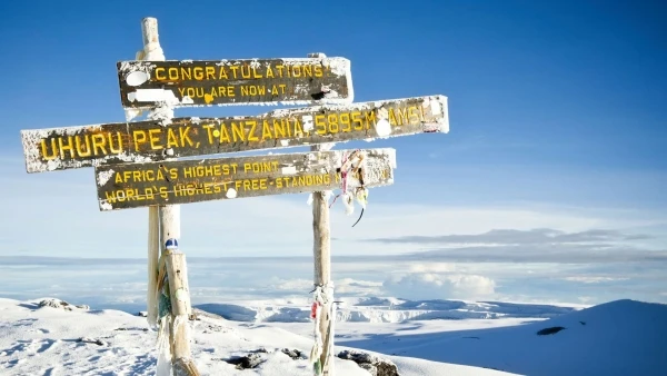
Kilimanjaro is a dormant volcano in northern Tanzania that covers a total area of 1,688 square kilometers (652 sq. mi, it stands at 5896m and is the highest peak in the whole African continent. It is also the highest free-standing mountain in the world and one of the world’s highest volcanoes. The mountain has three volcanic peaks which are Kibo, Shira, and Mawenzi. The park was established as a national park in 1977. Mt Kilimanjaro National Park is among Tanzania’s most visited parks, unlike the other northern parks, this isn’t a place for a wildlife view, although it’s there. Rather, people visit the area to trek the amazing snow-capped mountain on the equator, and to climb to the top of Africa.Kilimanjaro is a dormant volcano in northern Tanzania that covers a total area of 1,688 square kilometers (652 sq. mi, it stands at 5896m and is the highest peak in the whole African continent. It is also the highest free-standing mountain in the world and one of the world’s highest volcanoes. The mountain has three volcanic peaks which are Kibo, Shira, and Mawenzi.The park was established as a national park in 1977. Mt Kilimanjaro National Park is among Tanzania’s most visited parks, unlike the other northern parks, this isn’t a place for a wildlife view, although it’s there. Rather, people visit the area to trek the amazing snow-capped mountain on the equator, and to climb to the top of Africa.Mount Kilimanjaro is more popular than the country it’s in (Tanzania)Nearly every kind of ecological system is found on the mountain, cultivated land, rain forest, heath, moorland, alpine desert, and an arctic summit (Uhuru).Kilimanjaro is one of few places in Africa with permanent snow

  Rate : $165 to $5629

  Best time : August to October

  High season : August to October

Mount Meru

Mount Meru

Tanzania

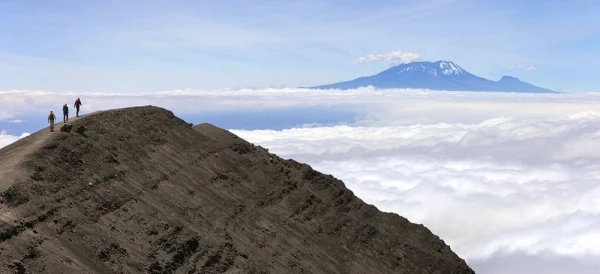
Mount Meru is a dormant stratovolcano located 70 kilometers (43 mi) west of Mount Kilimanjaro in the country of Tanzania. At a height of 4,562.13 meters (14,968 ft), it is visible from Mount Kilimanjaro on a clear day and is the fifth-highest mountain in Africa. Mount Meru is located just north of the city of Arusha,  It is the second-highest mountain in Tanzania, after Mount Kilimanjaro. Mount Meru is the topographic centerpiece of Arusha national park Its fertile slopes rise above the surrounding savanna and support a forest that hosts diverse wildlife, including nearly 400 species of birds, and monkeys & leopards.Mt Meru starts its steep rise from a circular base some 20km across at 2000m. At about 2500m some of the walls have broken away, so the top half of the mountain is shaped like a giant horseshoe. The cliffs of the inner wall below the summit are more than 1500m high, making them among the tallest in Africa. Inside the crater, more recent volcanic eruptions have created a subsidiary peak called the Ash Cone that adds to the scenic splendor.Tip: once in Arusha city (the safari hub of Tanzania) you will have great views of the Mount Meru Duration of a mount Meru hikeAlthough Mount Meru has been climbed in 1 day and 2 days is very reasonable, the park has a regulation stating that climbs of the mountain will take a minimum of 3 days with a recommendation for 4. Reasons to hike Mount Meru·         Wildlife viewing, on the lower slopes of the mountain hikers are likely to see elephants, giraffes, buffalo, etc.·         Stunning views, hiking mount Meru comes with rewarding views of the Arusha region and Mount Kilimanjaro.·         Mount Meru is a great option to try on and acclimatize as you prepare to hike Mount Kilimanjaro·         Mount Meru is a relatively cheaper and less challenging option to Kilimanjaro and can be done in a shorter time frame  Best time to hike Mount MeruYou can hike mount Meru all year round but during the dry season from June to early November is the best time, late January to march is also great. April may be avoided as it is the rainy season Getting to Mount MeruYou can fly (to Kilimanjaro international airport - jro or Arusha airport -ark) or take a bus to Arusha, from here you can take our guided trips to mount Meru  

  Rate : $50 to $1200

  Best time : June - October

  High season : no crowds year out

Oldoinyo Lengai

Oldoinyo Lengai

Tanzania

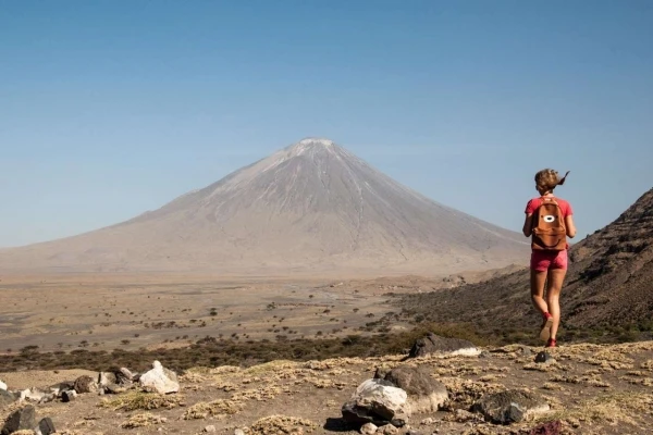
South of Lake Natron in the eastern rift valley of North Tanzania, lies Mount Ol Doinyo Lengai (locally regarded as the sacred Mountain of God in the Maasai Language), an active volcano. At 2878meters, Mt. Ol Doinyo Lengai is the only known volcano in the world that sometimes erupts natrocarbonatite lava, highly fluid lava that contains almost no silicon. Natrocarbonatite lava (the most fluid lava) is also much cooler than other lavas. During the day most of this lava flows look like fluid black oil. Some feel the lava flows resemble mud like-flows. Natrocarbonatite lava turns white when in contact with moisture.  During rainy periods, the lava turns white almost immediately whilst this whitening takes longer during dry periods.Mount Ol Doinyo Lengai also has phases of explosive activity during which the composition of the lava may contain much more silicate material. With this type of eruption, the initial phases of the eruption may include strong lava fountains but usually, there is no fluid lava, and ash eruptions accompanied by the ejection of rocks and explosions occur. The two most recent eruptions of this type occurred during 1966-1967 and 2007-2008.  Almost without fail, about every seven years Ol Doinyo Lengai erupts and plumes of smoke billow out of the crater. At other times it is possible to walk down into the crater, almost to the edge of the molten lava flows                                                                                     Reasons to hike mount Ol Doinyo Lengai:Ol ‘Doinyo Lengai is the only active volcanic mountain in the East African Rift Valley Region, this makes it special if you are keen on learning more about volcanic activitiesGreat Stunning Views, in the north from its summit crater lies the hot barren salt flats of Lake Natron stretch into the distance, and beyond lies the Kenyan border. The view on the east is dominated by Mt Kilimanjaro and to the west, the forested escarpments and hills comprise the western slopes of the Great African Rift Valley.Great detour or safari extension, when going on a Tanzanian northern circuit safari you can make an extension to lake natron where you can do several activities and hike mount Ol Doinyo Lengai which takes several hours.Cultural exploration, the mountain is surrounded by the Masai community which is one of Africa’s popular tribes, known for strong cultures and living a life outside of civilization. You can even have a Masai guide as you take on the hike Best time to hike Mount Ol Doinyo Lengai:Ol Doinyo Lengai can be trekked all year round, though the best time to tackle this mountain is during the dry season, from June to October, and from January to March, April & may be avoided as it is the rainy seasonHike durationIt takes 10 to 13 hours to hike Mount Ol Doinyo Lengai  Getting to Mount Ol Doinyo Lengai: You can hire a private vehicle heading to Lake natron, from here you will accommodate & prepare for the hike.

  Rate : $ to $

  Best time : June - October

  High season : no crowds year out

Udzungwa Mountains Np

Udzungwa Mountains Np

Tanzania

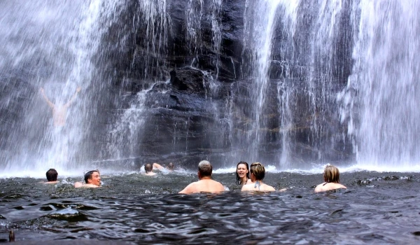
This mountain range from south to central Tanzania. The biodiversity of this park is by far one of Tanzania’s most special features making it ab intriguingly offbeat destination for anyone botanically inclined. Habitats include mountain forests, tropical rainforests, Miombo woodlands, grasslands, and steppe.The Udzungwa Mountains are part of the Eastern Arc Mountains which are found in Kenya and Tanzania and were formed some 200 million years ago. Today they hold a unique collection of flora and fauna and cover only 2% of Tanzania’s area but hold between 30-40% of the country's plant and mammal species. The vertical height of the Udzungwa forests ranges from 250 m to 2,576 m and with numerous forest trails, offering different kinds of activities, the park is a true hikers' paradise. A half-day tour to Sanje waterfall at a towering 170 m is definitely worth doing. The park is also home to 6 species of primates, 2 of which (Iringa red colobus and the Sanje crested Mangabey) occur nowhere else in the world. Bird watchers are also in for a treat as the park boasts with over 400 species of birds. Some of them are endemic to the Eastern Arc Mountains and four of them are found only in Udzungwa. Other common birds include ruppells vultures, marabous, crowned eagles, malachite kingfishers, woodland kingfishers, silvery-cheeked hornbills, and trumpeter hornbills.   Reasons to Hike Udzungwa Mountains;·         Birding and a walking safari, Four or the present bird species are peculiar to Udzungwa, you can also go out to explore primates and other mammals present in this biodiverse park.·         Udzungwa is a magnet for hikers. An excellent network of forest trails includes the popular half-day ramble to Sanje Waterfall, which plunges 170 meters (550 feet) through a misty spray into the forested valley below.·         Udzungwa mountains is also relatively cheaper and less challenging making a greater alternative for hikers who are not sure or ready to tackle Mount Kilimanjaro or Mount Meru which are higher, more challenging, and with a higher budget. Best Time to Hike the Udzungwa Mountains;The best time is during the dry season from June to October, however January to march is also great, you should avoid April to May which is the rainy season. Getting to the Udzungwa Mountains;You can hire a private vehicle or take a bus heading to Mikumi which is a small town just before the mountains.

  Rate : $ to $

  Best time : June - October

  High season : no crowds year out

Uluguru Mountains

Uluguru Mountains

Tanzania

The Uluguru Mountains are found within Morogoro Region. The main Uluguru Mountains is a ridge running approximately north-south and rising to 2,630 m altitude at their highest point. The greater Uluguru area also includes a number of isolated massifs surrounding the main block. On the main Uluguru range, villages touch the forest boundary and over 151,000 people are found within the mountain area, often at increasing densities at higher altitudes up to the forest boundary.For over three centuries the mountain and its surroundings have mainly been the home to the Luguru, the main tribe in the area. The name means “people of the mountain” and most of them now live in and around the mountains, mainly with agriculture as their way of surviving.Uluguru can show you some of the world’s richest and most species-diverse rainforests, containing more than ten endemic reptilian and amphibian species and over a hundred endemic plants, including African violet, busy Lizzie, and begonias. Of the mammals, you can meet here are yellow baboons, blue monkeys, black and white colobus monkeys, wild pigs, and duiker antelopes, but still, the mountains are most known for their birdlife.  Things you can do at Uluguru mountains:Hiking is a popular to-do activity with the scenic beauty of the mountains you are set for an amazing experience. This mountain is also relatively cheaper and less challenging for many hikers than Tanzania’s blockbusters (Mount Kilimanjaro & mount Meru). Visiting Choma waterfalls, seeing a waterfall is usually a great sight but even more satisfying after hiking through green and scenic vegetation Bird watching & walking safari, with over 15 species of birds and different types of monkeys in the forest it is great going out to explore and have a closer look at the inhabitants.Visiting plantations, with the Uluguru community being one of the popular hardworking farmers in Tanzania, visiting their farms shouldn’t be something to miss out  Best time to hike Uluguru Mountain:The best time is during the dry season from June to October, however January to march is also great, you should avoid April to May which is the rainy season. Getting to Uluguru:You can hire a private vehicle or take a bus heading to Morogoro which is a small town just before the mountains.   

  Rate : $ to $

  Best time : June - October

  High season : June - October

Usambara Mountains

Usambara Mountains

Tanzania

The Usambara mountains situated in the northeastern part of Tanzania are known for their cool lovely climate, stunning viewpoints, wide panoramas, winding pathways, attractive vegetation, and productive slopes favored in the colonial era, the area is rich in history making it one of Tanzania’s highlights. These range mountains are part of the ancient eastern Arc chain which stretches in a broken curve from the Taita hill in south Kenya to the southern highlands in Tanzania.The range is accessible from the towns of lushoto in the west and Amani in the east, split into two sub ranges the west Usambara and the east Usambara. The east is close to the coast receiving more rainfall and it is smaller than the westTravelers go to the Usambara to enjoy its nature, relax and hike however from the main center of visitors the lushoto town you can walk through the arboretum, look at old colonial buildings, stop at the herbarium which houses thousands of pressed plants dating back to the colonial era (1886-1916)These mountains are a stop you wouldn’t want to miss if you are out to explore Tanzania, 2 or 3 days are adequate you can spend more if you are looking to cover places of interest on the east Usambara  Reasons to hike the Usambara mountains:These mountain ranges are one of the most favored hike locations in Tanzania with their beauty and a relatively lower budget in comparison to Mount Kilimanjaro, mount Meru & mount oldonyo Lengai, it is a moderate hike and suitable for visitors of wide fitness levels. Here are other reasons why you should hike the Usambara.Views:Is it even a great hike if you won’t be amazed by the views? hiking the Usambara mountains will take you through sweeping hills, valleys, farmland, and villages and a rewarding view from the top.Culture:The Usambara is remotely located so you’ll get to see a lot more about Tanzanian people and how those who are far from the major cities live, you will experience life more dependent on your environmentRelaxation:Even though it’s a three-day to four-day hike and you’ll cover 15-20km (10-15 miles) every day, it’s less challenging. There are some brief uphill sections. The hike relaxing as it is a chance to get away from civilization and experience a few days in the countryside.Irente viewpoint in Usambara mountains:From Lushoto, hike to this outlook for remarkable views of the village of Mazinde and the Maasai plains almost 1000 meters below. Eat lunch at the Irente Biodiversity Farm in their beautiful flower gardenMagamba rainforest in the Usambara mountains:Walk through villages and farmland to the lavish rainforest where you can see black-and-white Colobus monkeys, colorful butterflies, and two-horned chameleons.Usambara flora and fauna (plants and animals):The vegetation at Usambara is green and amazing to look at, walking through the farmland and learning a lot about the vegetation of the area is a great experience  Things you can do at Usambara mountains:HikingCampingMountain bikingWalking safariVisiting waterfallsYou can also head to east Usambara to magoroto forest or Muheza  Best time to hike the Usambara Mountain:The best time is during the dry season from June to October, however January to march is also great, you should avoid April to May which is the rainy season.  Getting to Usambara:You can hire a private vehicle or take a bus heading to lushoto which is a small town just before the mountains.

  Rate : $780 to $780

  Best time : June - October

  High season : no crowds year out